The purpose of this guide is to orient scientists and other data users to California’s commercial halibut trawl logbook data. These data are confidential and are only provided through authorized data sharing agreements. This guide seeks to help scientists and other data users anticipate how these data are formatted and how they may have to “clean” (a.k.a., process) the data before they can be used in analysis. I also seek to highlight special tricks and caveats gleaned from my experience using the data. Ultimately, I hope this guide will help clarify what data are available and how these data can be processed to maximize their utility.
Overview
The California Department of Fish and Wildlife (CDFW) has been compiling catch statistics on California’s fisheries since 1916. CDFW has required commercial halibut trawl vessels to submit logbooks since 1982. These logbook data record start and end haul locations, time, depth, and duration of trawl tows, total catch by species market category, gear used, and information about the vessel and crew. Additional information is available here.
This guide provides an overview of California’s commercial halibut trawl logbook data based on a data request processed in January 2024 for all halibut logbooks from 1982-2023. In this guide, I review the attributes of the halibut trawl logbook data, the steps required to clean the raw data, and some visualizations of non-confidential summaries of the halibut data.
Logbook overview
The Trawl Log database includes all data from the Trawl Log (DFG 176) and some data from the Shrimp/Prawn Trawl Log (DFG 120), but only from tows where federal groundfish are caught. While the Trawl Log is used primarily by federal groundfish trawl permittees, California halibut bottom trawl permittees also use Trawl Log (DFG 176) as do some sea cucumber trawl permittees. Trawl Logs are submitted by the 10th of the month to local CDFW field offices where Pacific States Marine Fisheries Commission (PSMFC) staff edit the logs, add landing receipt numbers (if available), and enter the data into the database. Additional QA/QC is done bimonthly by PSMFC staff who make the final match of logs to the landing receipts and add in the converted weight of the catch among other fields (see table below for complete list of added fields). This database is also uploaded to PacFIN; in the past, this was done three times per year, but changed to nightly in 2016 after CDFW’s data entry program broke and was replaced by PSMFC’s trawl log data entry program adapted from their E-logs program.
Since trawl logs are entered by PSMFC staff, the data entry program resides on a PSMFC server and is maintained by PSMFC. Nightly feeds from PSMFC ensure that CDFW has up to date trawl log data, including any changes to the data. All edits to the logs occur on the PSMFC end and CDFW has to request that PSMFC make any necessary changes. The Trawl Log Extract/Report and Trawl Log Counts Report are part of CDFW’s Marine Landings System.
Trawl Logs were originally a state logbook required by Title 14, CCR, Section 176. The same trawl logbook was used for all federal groundfish trawl activity by fishers from the states of California, Oregon, and Washington. Changes to the format of the trawl log were discussed and agreed upon by the three member agencies (CDFW, ODFW, WDFW). PSMFC paid for trawl log printing costs. CDFW provided postage paid envelopes to trawl fishermen to return their logs. Trawl logs were to be postmarked by the 10th of the month following fishing activity.
In 2018, the Fish and Game Commission decided to remove the trawl logbook requirement for federal groundfish, and NOAA Fisheries established a federal rule requiring the groundfish trawl logbook. Thus, on July 1, 2019, it became a federal requirement for California groundfish fishers to complete the federal log (same log, just different ownership). California halibut trawl fishers are still required to submit the Trawl Log (DFG 176) (Title 14, CCR, Section 176). Because trawl logs include both state data for non-groundfish fisheries and federal groundfish, CDFW continues to receive a nightly feed of all trawl logs from PSMFC.
Physical copies of Trawl Logs are stored in CDFW’s San Carlos office for 5 years (per CDFW records retention schedule), then scanned and destroyed by PSMFC staff. Scanned copies of trawl logs are kept and go back to 1987, although early years may not be complete.
Data attributes
The halibut trawl logbook data includes the following columns:
| Column | Description |
| SerialNumber | Logbook id |
| VesselID | Vessel id (e.g., 12345) |
| VesselName | Vessel name |
| CrewSize | Crew size, including captain |
| DepartureDate | Date of departure |
| DepartureTime | Time of departure (HH:MM) |
| ReturnDate | Date of return |
| ReturnTime | Time of return (HH:MM) |
| DeparturePortCode | Departure port code |
| ReturnPortCode | Return port code |
| SetMonth | Month of tow start |
| SetDay | Day of tow start |
| SetYear | Year of tow start |
| TowNumber | Tow number |
| TowHours | Tow duration (hrs) |
| SetTime | Time of tow start (HH:MM) |
| SetLatitude | Latitude (°N) of tow start |
| SetLongitude | Longitude (°N) of tow start |
| UpMonth | Month of tow end |
| UpDay | Day of tow end |
| UpYear | Year of tow end |
| UpTime | Time of tow end (HH:MM) |
| UpLatitude | Latitude (°N) of tow end |
| UpLongitude | Longitude (°N) of tow end |
| AverageDepth | Average depth (fathoms) |
| NetType | Net type |
| CodendCapacity | Cod end capacity – empty field |
| TargetStrategy | Target species PACFIN code (e.g., ABCD) |
| EstimatedPounds | Catch estimated at sea (lbs) |
| TicketPounds | Catch prorated based on landing receipt (lbs) |
| SpeciesCode | Species code (e.g., 123) |
| PacFINSpeciesCode | PACFIN species code (e.g., ABCD) |
| Revenue | Ex-vessel revenue (USD) |
| Region | Region |
| Block | Block id |
| IsEFPTrip | Under a experimental fishing permit (Y/N)? |
| IsEMTrip | Was electronic monitoring used (Y/N)? |
| IsObservedTrip | Was an observer on board (Y/N)? |
| LandingReceipt | Landing receipt ids |
| LandingDate | Landing receipt dates |
| IsSigned | |
| IsVoid | |
| Comments | Comments |
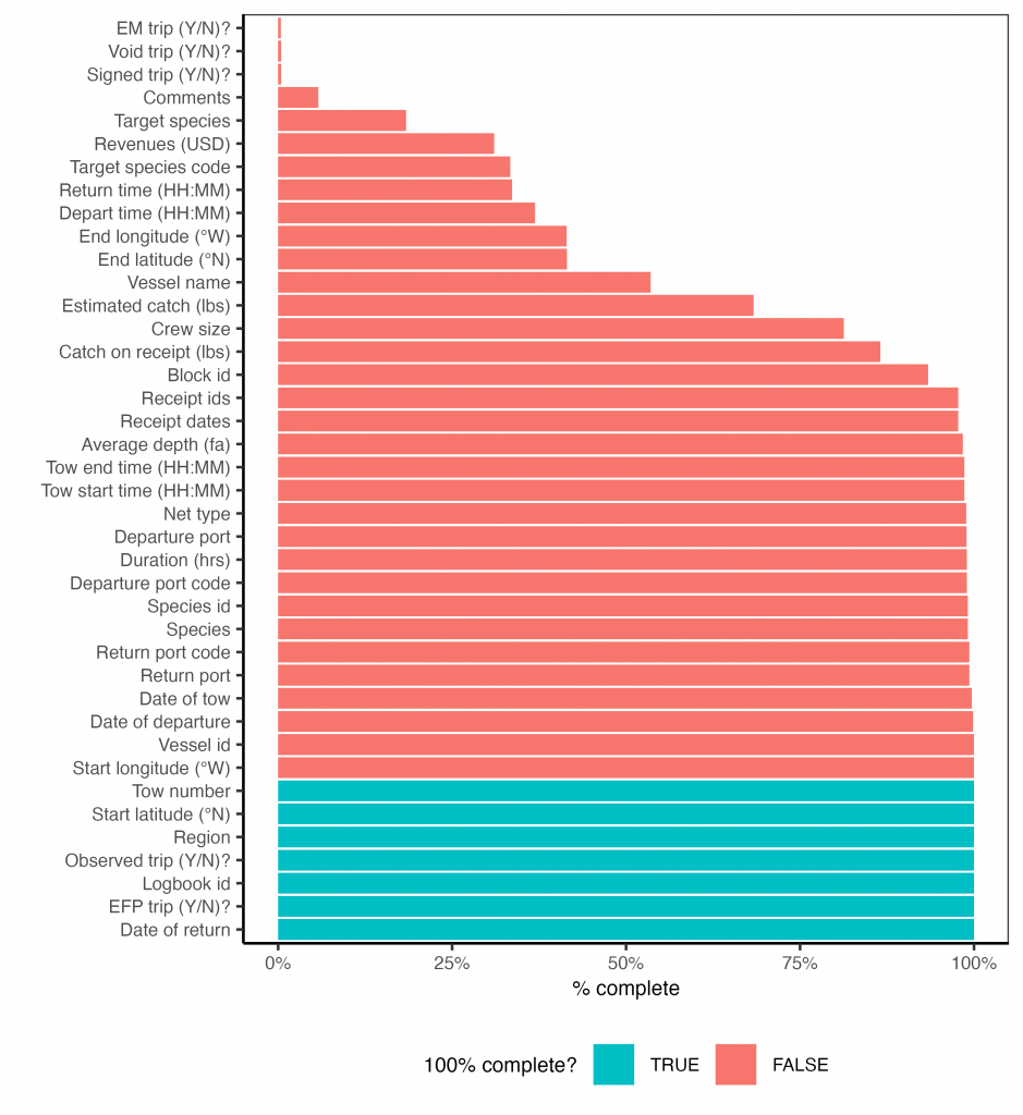
Attribute completeness
The figure below illustrates how consistently each attribute was filled out.
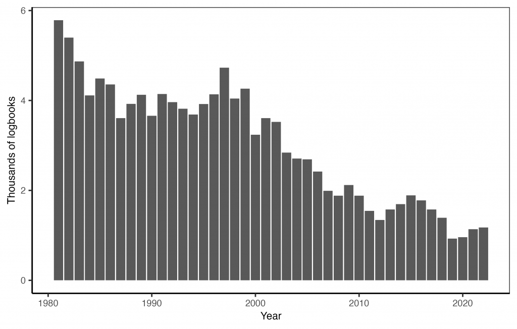
Number of logbooks by year
The figure below illustrates the number of logbooks submitted over time.
Attribute information and issues
Logbook id
The logbook id (“SerialNumber”) is a unique identifier for each logbook page. Note that a trip could potentially span multiple logbook pages or that a page could include multiple trips.
Vessel id and name
The vessel id (“VesselID”) is a 5-number unique identifier assigned to each vessel by CDFW. The vessel name (“VesselName”) is the name of the vessel. The vessel name is missing for many vessels but the vessel id column is roughly complete. These missing values could be filled through examination of another dataset or by querying this resource.
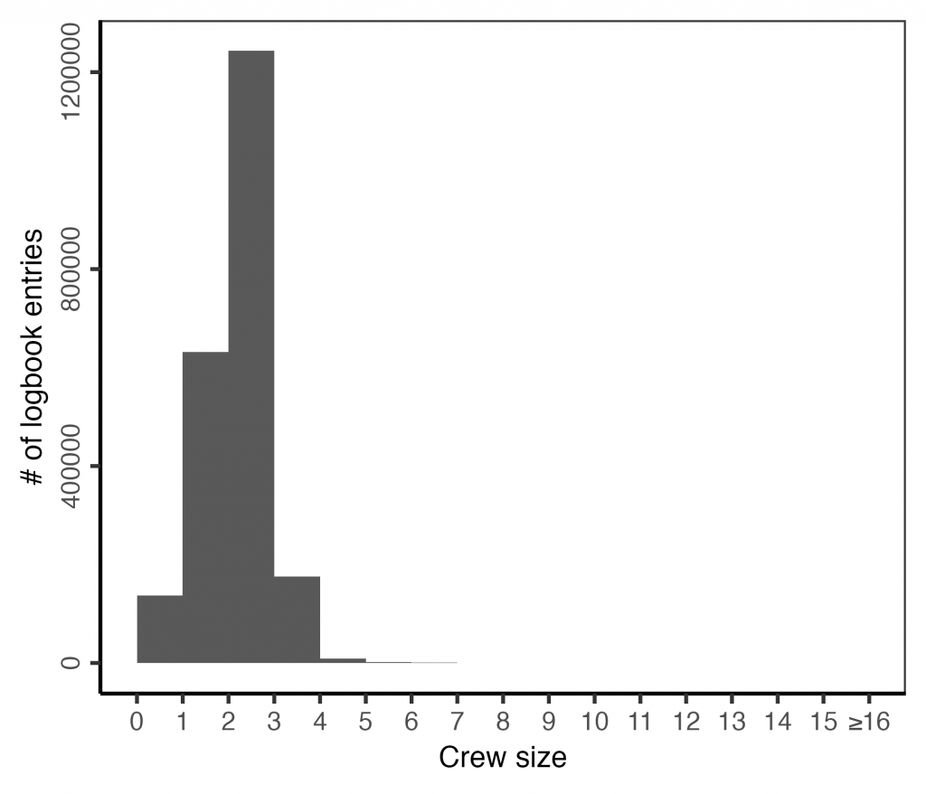
Crew size
The crew size (“CrewSize”) includes the captain. The field includes a few unrealistically large values.
Departure, return, and tow dates
These columns describe the date of departure (“DepartureDate”) and return (“ReturnDate”).
The date of the tow must be constructed from the year (“SetYear”), month (“SetMonth”), and day (“SetDay”) of the tow. The data include fields to describe the date the tow ends but these are all empty (“UpYear”, “UpMonth”, “UpDay”).
The time of departure and return is reported though rarely. These time are reported in 24-hour format as HHMM, HMM, MM, or M. I pad the times with zeros on the left and insert a colon to make them more easily readable and parseable. I also convert them to decimal hours to make them more ready for analysis.
Port code and name
The port of departure (“DeparturePortCode”) and return (“ReturnPortCode”) are identified using a 3-number code. I provide a key to relate these codes to their names and complexes here. There are a few invalid port codes.
Region
The region (“Region”) is defined as follows:
- N = North (North of 40° 10′)
- NC = North Central (between 40° 10′ and 36°)
- C = Central (between 36° and 34° 27′)
- S = South (below 34° 27′)
This field is added by CDFW.
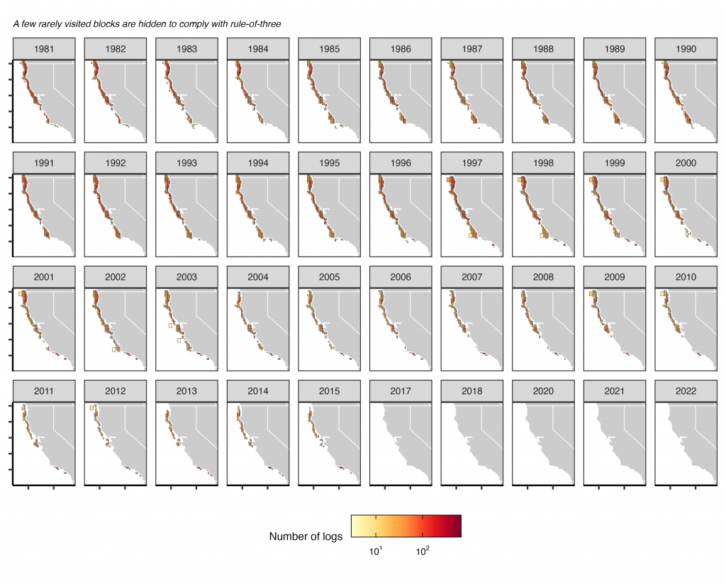
Block id
The effort is reported to statistical reporting blocks. The figure below shows the diminished effort in the halibut trawl fishery over time.
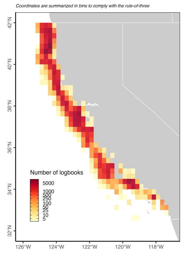
Set and up location
The longitude and latitude at the start of fishing is recorded “when the brake is set”. The longitude and latitude at the end of fishing is recorded “when the haul back starts”. GPS positions are nearly universal and unlike the positions reported in other logs, do not often fall on land (i.e., they appear realistic). Reliable coordinates could be identified as coordinates that fall within the reported block id.
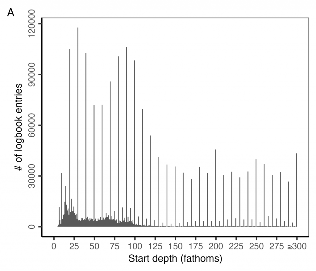
Average depth (fathoms)
This column (“AverageDepth”) records the average depth of fishing in fathoms. Logs used to record start and end depth. CDFW computed the average depth for these older logs.
The figure below shows that it is common to report depth to rounded 10s (10, 20, 30, 40 fathoms, etc) rather than to the exact depth.
Net type
The net type (“NetType”) is one of the following:
- B = bottom: A funnel or cone-shaped net towed through the water by a fishing vessel. The otter boards (doors) or footrope of the net are in contact with the seabed.
- D = Danish or Scottish seine: A cone-shaped net with long warps. The warps are hauled-in, herding the fish toward the cone-end of the net.
- F = selective flatfish: Modified small footrope trawl gear. Must be a two-seamed net and its breastline cannot be longer than 3 ft (0.92 m) in length. There may be no floats along the center third of the headrope and the headrope must be at least 30 percent longer in length than the footrope. May not have a footrope that is longer than 105 ft (32.26m) in length.
- L = large footrope: Footropes greater than 8″ in diameter (includes rollers, bobbins, or other material encircling or tied along the length of the footrope).
- M = midwater: A funnel or cone-shaped net towed through the water by a fishing vessel. The otter boards (doors) may be in contact with the seabed, but the footrope of the net always remains above the seabed
- S = small footrope: Footropes of 8″ or less in diameter (includes rollers, bobbins, or other material encircling or tied along the length of the footrope). Also, chafing gear may only be used on the last 50 meshes of a small footrope trawl, running the length of the net from the terminal (closed) end of the codend.
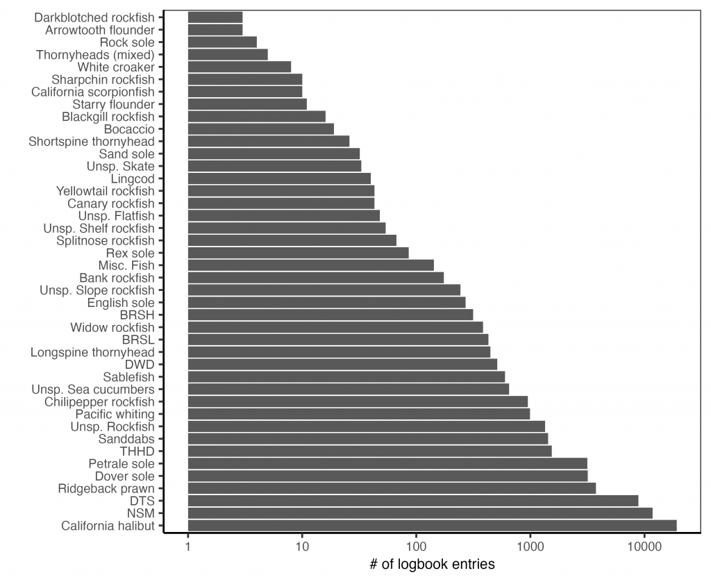
Target species
The target species (“TargetStrategy”) is reported using PACFIN species codes. The following codes are not formal PACFIN codes: BRSH, BRSL, DTS, DWD, NSM, THHD.
Of these, I received an official explanation for three codes:
- DTS = Dover sole, thornyheads, sablefish
- DWD = Deep-water dover sole
- NSM = Nearshore mix
Tow number
The tow number (“TowNumber”) column describes the order of the tows.
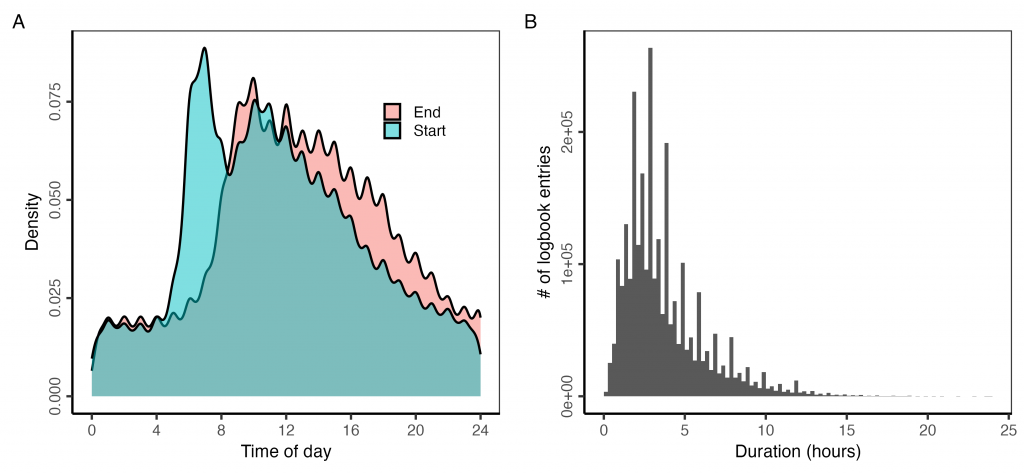
Set time, up time, duration
The start (“StartTime”) and end (“EndTime”) times are in 24-hour format as HHMM, HMM, MM, or M. I pad the times with zeros on the left and insert a colon to make them more easily readable and parseable. I also convert them to decimal hours to make them more ready for analysis. A few times are reported over 2400 and need to be converted (e.g., 2413 to 00:13).
The duration (“TotalTime”) column describes the duration of the fishing effort in minutes. The reported duration generally matches a duration derived from the reported start and end times. However, sometimes the reported duration, which I assume is calculated by CDFW, is incorrect. I use the derived duration and only use the reported duration when the derived duration is not available.
Species id and name
There are 216 species documented in the catch. The species require heavy formatting to be useful because they are sometimes reported using a CDFW species code and sometimes reporting using a PACFIN species code. I harmonize to the CDFW species code.
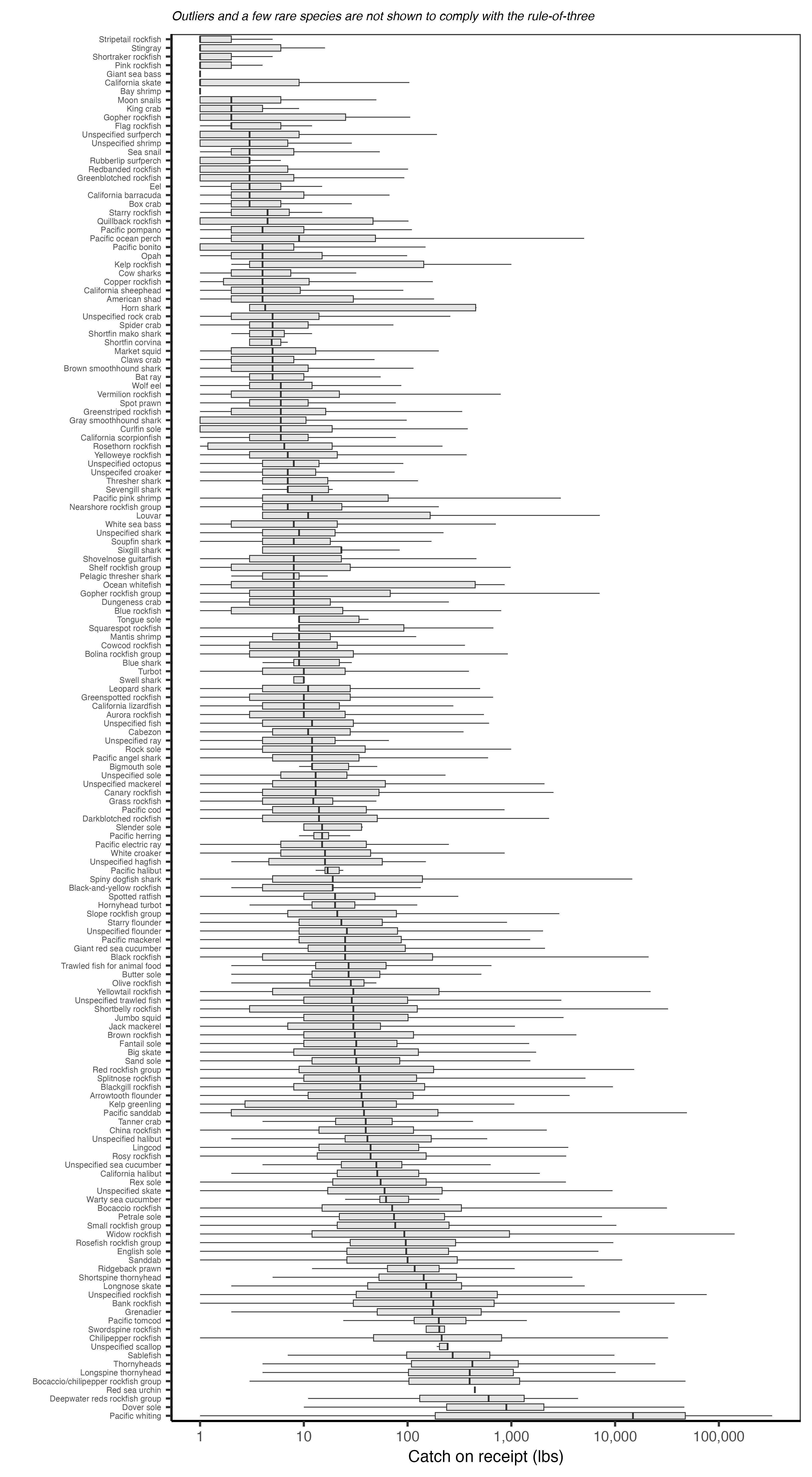
Estimated catch (lbs)
This column (“EstimatedPounds”) reports the amount of catch per tow estimated (hailed) by the captain at sea. It is reported in pounds (lbs).
Final estimated catch (lbs)
This column (“TicketPounds”) reports the amount of catch reported on the receipt and apportioned to the tow. The amount apportioned to the tow is based on the proportion hailed by the captain.
Revenue
This column (“Revenue”) provides the ex-vessel revenue associated with a tows catch. It’s calculated by multiplying the prorated pounds by the ex-vessel price ($/lb).
Receipt ids and dates
These columns provide a comma separated list of the landing receipts (“LandingReceipt”) associated with the trip and the dates associated with those landing receipts (“LandingDate”).
Comments
This column (“Comments”) records any comments made in the remarks section of the log.
EFP trip?
This column (“IsEFPTrip”) indicates whether the trip was conducted under an Experimental Fishing Permit. It was added to the log in 2009.
Observed trip?
This column (“IsObservedTrip”) indicates whether an observer was onboard during the fishing trip. It was added to the log in 2009.
EM trip?
This column (“IsEMTrip”) indicates whether electronic monitoring was used during the fishing trip. It was added to the log in 2009.